Researchers have developed a novel algorithm that significantly improves the detection of soil freeze-thaw transitions from space. This advancement addresses the limitations of existing methods that struggle to account for regional variations in land cover and climate conditions. The study, conducted by teams from Fudan University, the University of Twente, and Chengdu University of Information Technology, was published on September 10, 2025, in the Journal of Remote Sensing.
Soil freeze-thaw (FT) transitions are critical processes that impact surface albedo, moisture levels, and heat exchanges, all of which play a significant role in weather patterns and hydrological cycles. Traditional models often overlook the diurnal soil temperature variations and surface heterogeneity, leading to inaccuracies in large-scale monitoring. The new algorithm leverages L-band microwave remote sensing, known for its sensitivity to soil moisture and ability to penetrate snow and vegetation, providing a more reliable approach.
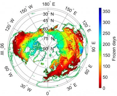
The researchers introduced a framework that optimizes parameters dynamically, enhancing the accuracy of soil FT mapping using data from the Soil Moisture Active Passive (SMAP) satellite. The enhanced model refines the existing Diurnal Amplitude Variation-based Freeze-Thaw (DAV-FT) algorithm by employing three key parameters—α, β, and γ. These parameters represent detection period, variance window, and threshold sensitivity, respectively. By applying techniques similar to maximum likelihood estimation, the algorithm maximizes overall classification accuracy across diverse regions.
Results indicate a substantial improvement, with areas achieving an overall accuracy (OA) greater than 0.7 expanding from 54.43% to 89.36%. The algorithm performed best in the Qinghai–Tibet Plateau, southwestern Eurasia, and southern North America. Validation efforts using 828 in situ soil temperature stations demonstrated a median accuracy of 0.92, outperforming both fixed-parameter models and existing SMAP products.
Dr. Shaoning Lv, the study’s lead author, emphasized the importance of this advancement. “The dynamic parameter optimization significantly enhances our ability to capture subtle soil freeze-thaw transitions that vary across regions and seasons,” he stated. He noted that the method not only improves the retrieval accuracy of L-band data but also offers a more coherent understanding of land-atmosphere interactions, marking a significant step toward enhanced climate monitoring.
The improved DAV-FT algorithm emerges as a robust framework for ongoing monitoring of soil freeze-thaw cycles across different terrains. This is particularly valuable for climate modeling, agricultural management, and hydrological forecasting. Its capacity to adapt to diurnal temperature cycles and regional differences makes it especially beneficial for high-latitude and mountainous regions, where current algorithms face challenges.
By enhancing the accuracy of soil state detection from space, this method lays a stronger foundation for assessing permafrost dynamics, water availability, and land-atmosphere energy fluxes. These factors are crucial for predicting the impacts of climate change and improving global land-surface models.
This research received funding from various sources, including the National Key R&D Program of China, the Key Research and Development and Achievement Transformation Program of Inner Mongolia Autonomous Region, the Yan Liyuan–ENSKY Foundation Project, and the National Natural Science Foundation of China.
In conclusion, the new algorithm represents a significant leap in the realm of remote sensing, potentially transforming how scientists monitor and understand soil dynamics in a rapidly changing climate.