URGENT UPDATE: A significant winter storm is set to impact Western Colorado starting tonight, with heavy snowfall and dangerous travel conditions expected through Thursday morning. Travel disruptions are anticipated across the Western Slope, Front Range, and routes toward Metro Salt Lake City.
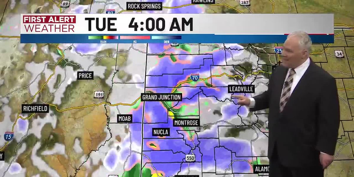
A Winter Storm Warning is in effect from 11 PM Monday until 5 AM Thursday for the Grand Mesa, San Juan Mountains, and other key areas. Snow accumulations of 10 to 18 inches are predicted, with wind gusts reaching 60-70 mph. These conditions will create near-zero visibility and make mountain travel difficult to impossible.
Travelers are advised to take extreme caution. The warning encompasses popular routes and destinations such as Vail Pass, Telluride, and Monarch Pass. As conditions worsen, many areas could see snowfall totals exceeding 2 feet in higher elevations, particularly the central Elk Mountains and around Wolf Creek Pass, where totals could reach up to 3 feet.
In addition to the winter storm, a Winter Weather Advisory is in effect from 11 PM Monday until 5 AM Tuesday for the Roan and Tavaputs Plateaus, with 4-10 inches of snow expected in those regions. Wind gusts in the advisory area could hit 60 mph, creating further travel hazards.
A Wind Advisory will also impact much of Southwest and Northwest Colorado from 5 AM Tuesday until 5 PM Tuesday. Wind gusts of up to 50 mph are possible across the Yampa River Basin, Paradox Valley, and Animas River Basin, affecting towns like Craig, Meeker, and Durango.
The storm will unfold in multiple waves, with the first round of rain and snow expected between midnight and 6 AM Tuesday. Additional precipitation will follow throughout Tuesday, with significant accumulations anticipated by Wednesday morning.
Valley conditions may see minimal accumulation early in the week, with 1-2 inches of snow likely. However, higher elevations will bear the brunt of the storm, leading to treacherous travel. Motorists should prepare for challenging conditions and stay updated as weather patterns shift.
The forecast for Monday calls for cloudy skies with temperatures ranging from the mid-30s to low-50s by noon, peaking near 61 degrees in Grand Junction. However, these pleasant conditions will give way to severe winter weather by nightfall.
Stay tuned for updates as this winter storm develops. Travel safely and monitor local advisories.